Life and Times of Moses Helm: Myth and History
Gary Helm
Updated January, 2021
Copyright © 2009 -2024 Gary Helm
MOSES HELM and ROADS in BEDFORD COUNTY VIRGINIA
December
23, 1754: Moses Hellum, Wm: Moore, Thomas Franklin, John Bollings
Tiths, William Rutherford, James Murphy, James Wheeler, John
Gallaway, Archibald Campbell, James Machvenals, Edm: Fair, Nicholas
Hays, Lewis Franklin, Edmond Franklin, John Thompson, John Pleasants
Tiths, Nathn: Paterson, Hugh Bowles and
John Carson
Ordered to work on the Road whereof John Beard is Overseer.1
The first documentation of Moses Helm living in Virginia is in the Bedford County Court Book on December 23, 1754. Moses Hellum, a phonetic spelling of Moses Helm, is ordered to work on the road where John Beard is Overseer. All subsequent spellings of Moses Helm in Bedford County are spelled as we would spell Helm.
MYTH 1:
Contrary
to various
family traditions based a misreading and misunderstanding of this
court record, Moses Helm did not have a contract to survey and build
a new road in Bedford County Virginia. However, this document does
tell us, Moses Helm lived in Bedford county during 1754, and he lived
somewhere in the vicinity of the road where John Beard was the
Overseer.
Where was the road where John Beard was the Overseer?
LUNENBURG COUNTY ROAD ORDERS 1746-1764; pdf 93-r17
The establishment and maintenance of public roads was one of the most important functions of the County Court during the colonial period in Virginia. Each road was opened and maintained by an Overseer of Highways appointed by the Gentlemen Justices yearly. He was usually assigned all the Laboring Male Titheables living on or near the road for this purpose. These individuals then furnished all their own tools, wagons, and teams and were required to labor for six days each year on the roads.
The road orders contained in this volume cover the period from 1746, when Lunenburg’s county government first became operational, through the creation of Halifax in 1752 and Bedford in 1754, down to the creation of Charlotte and Mecklenburg from it in 1765. As such, they are the principal extant evidence concerning the early development of roads over a vast area of Southside Virginia stretching into the very shadows of the Blue Ridge to include Pittsylvania, Henry, Franklin and Patrick, as well as major portions of Appomattox, Bedford and Campbell counties.
Lunenburg included the modern counties of Lunenburg, Mecklenburg, Charlotte, Halifax, Pittsylvania, Henry, Patrick and Franklin, as well as portions of Bedford, Campbell, and Appomattox counties.
2 June 1746 Old Style, Page 13
John Beard is Appointed overseer of the same Road from the Poplar Spring to his Road at the head of Appomattox river And it is Ordered that all the Male laboring Tithable Persons convenient thereto assist in clearing the same.2
ALBEMARLE COUNTY ROAD ORDERS 1744-1748
14 Aug. 1746 O.S., p. 142
Ordered that a Road be Cleared from Beards Road on the Ridge between Appomattox and Willis?s the nearest and best way to Albemarle Court House And alls that the Old road from Brooks Mill to John Bosticks be kept Open and that John Gannaway Stephen Sanders Joel Walker Daniel Low Edmond Gray and John Childers with their Male Tiths do Clear the same John Childers Overseer./.3
The answer to the question is, John Beard was the overseer of several roads and specific to where Moses Helm lived, there two: John Beard was the overseer of a road which had been in Lunenburg County, and a road which had been in Albemarle County, both of which in 1754 were in Bedford County.
The Lunenburg order is an example of court order for a road being made, and both the Albemarle and the Lunenburg orders, both in 1746, are examples of an existing road being used as a point of reference for making new roads.
In 1753 that portion of Lunenburg containing the road between Poplar Spring and John Beard’s Road at the head of the Appomattox River became part of Bedford County. In one of Moses Helm’s deeds this road is referred to as Beards old path.
In 1754, when a portion of Albemarle County was added to Bedford County, Beard’s Road on the ridge between Appomattox and Willis’ became part of Bedford County. The location of this road was referred to in Goochland records, before the formation of Albemarle County, and in one of Moses Helm’s deeds this road is referred to as the county road.
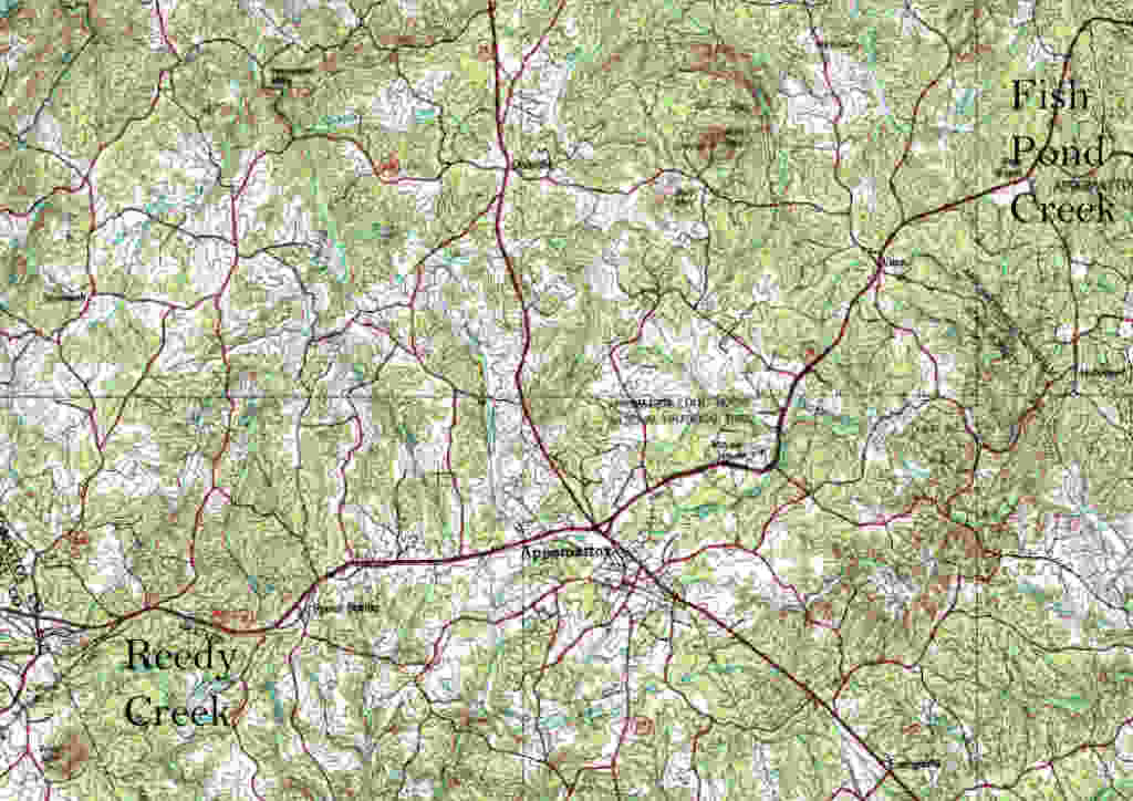
Together these roads extend from the headwaters of the Willis River near Willis Mountain, in what is now Buckingham County Virginia, across what is now Appomattox County, and to Poplar Spring near Long Mountain, in what is now Campbell County.
We are benefited by the fact the names of the persons are listed in this road order. Most road orders merely say all tithables.
Who were the Tithables?
The tithable lists, of all males over the age of 16 living in a given area, were required to be registered by June 6, and this list was used by the courts during the subsequent year. 4
The road order does not tell us where Moses Helm was living in Bedford Count in 1754, whether it was on one of two properties which he would later have documented own. One of the properties was on the county road between the headwaters of the Appomattox and Willis Rivers, and had been in Albemarle County. And the other property had been in Lunenburg County on “Beards old path.” Moses could have also been living on another property which documents for have not been found. Either way, we can know Moses was living in Bedford County in 1754.
THE WARS IN VIRGINIA DURING MOSES HELM’S LIFETIME
1754 – 1763 French Indian War: Bedford County was attacked by several groups of Indians during the French and Indian War.
Moses Helm did not select the most peaceable time to move his family to Bedford County Virginia. In 1756, raids in Virginia penetrated into Bedford, Halifax, and Albemarle Counties. “Settlers deserted an area from the Delaware River to the Roanoke River, a distance of nearly four hundred miles long and between fifty and one hundred miles wide. The population of Augusta County, Virginia fell by nearly half from 1754 to 1758.”5
In mid-July [1757] a raiding party attacked southern Augusta County, penetrating deep into Bedford County, Halifax, and even Lunenburg Counties.6
Raiding parties descended on the Virginia frontier in April [1758] and devastated a large area, killing or capturing over sixty settlers in Augusta, Bedford, Halifax, and Albemarle Counties. Hundreds more fled in panic. Their panic was heightened when on April 27 the raiders destroyed Upper Tract Fort and then on the following day descended upon Fort Seybert. Believing they would be allowed to return to Virginia, the garrison surrendered. However, the Indians seized the garrison, killing sixteen and taking the remaining twenty –four into captivity.7
1759 to 1761 The Cherokee War
While Britons and colonists alike basked in victory in Canada, the backcountry of Virginia remained violent, as the Anglo-Cherokee relations broke down and resulted in a new frontier war. The Cherokee War that descended upon the backcountry of the Carolinas and southwest Virginia from 1759 to 1761 had many of its origins in the diplomacy of the Seven Years’ War. …. Shawnee raids into Bedford and Halifax Counties, along the routes traversed by Cherokee warriors, further complicated Anglo-Cherokee relations. Local inhabitants could not distinguish between Cherokee allies and Shawnee enemies and treated all Indians with similar enmity.8
Peace had finally been concluded, but in Virginia the Cherokee War left a legacy of deep popular resentment. While the bulk of the devastation caused by the war was on the Carolina frontier, Augusta, Halifax, and Bedford Counties in southwest Virginia had all suffered from Cherokee raids and particularly major raids on Halifax County in the spring of 1758 and on Augusta and Halifax Counties in May and June 1760.9
1773-1774 Dunmore’s War
1776-1782 American Revolution:
Moses Helm’s two sons, three son-in-laws who served as officers during the revolutionary war:
1. Son: Thomas Helm, Captain, severed in Virginia, South Carolina and North Carolina from at least 1778 until his death in 1781. Captain Thomas Helm died as result of wounds received during the battle at Guilford Courthouse;
2. Son: John Helm, Second Lt Bedford militia;
3. Son-in-law: Alexander Steel married to Elizabeth Helm (Virginia Militia Part 3 p 188) First Lt, S Nov 22 1779;
4. Son-in-law: James Dixon married to Susannah Helm. Cpt. James Dixon was wounded in the battle of Guilford Court House (per Long Obstinate and Bloody), and Gabriel Duncan pension S-10588, states in the spring 1777 he served under Col James Dixon);
5. Son-in-law: James Dinwiddie married to Sarah Jameson Helm (John Pribble pension S5951 states he served under Capt Thos Helm and Lieutenant James Dinwiddie [Thomas Helm’s brother-in-law], and ensign John Steele [Thomas Helm’s nephew]).
MOSES HELM’S PROPERTIES
MYTH 2
The myth is Moses first settled in Bedford County. The Road Order substatiates he first settled in Albemarle County Virginia, before a portion of that county became part of the new county, Bedford.
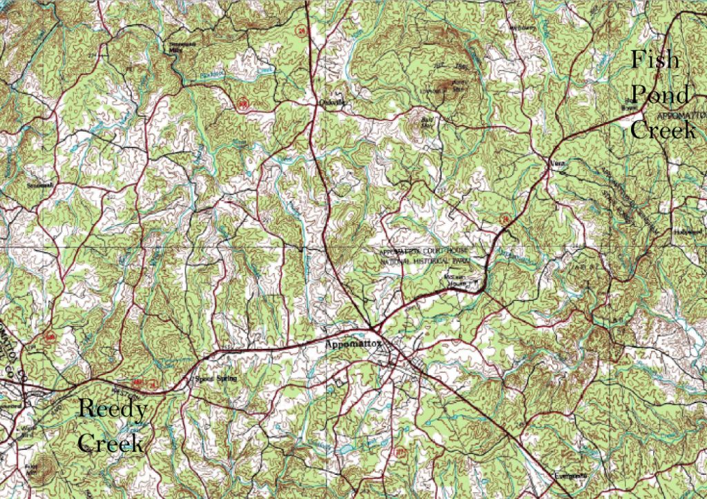
Property on Fishpond creek
Documentation
in 1754 and 1760 verify Moses Helm owned property
on Fishpond Creek. First is the Road Order where Beards This is
Beards Road, which is later known as the old Richmond Road between the headwaters of the Appomattox River and
Willis River with the county road going through Moses property on Fishpond Creek.
Second, the property on Fishpond Creek is shown to be in Albemarle County, which means the grant dated 1760 was begun before the formation of Bedford County.
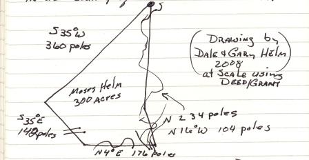
July 15, 1760: Moses Helm receives the grant for 300 acres in Albemarle County Virginia, on both sides of Fish Pond Creek, on the Appomattox River, and the grant is signed by Fran. Fauquier. The grant shows Fish Pond Creek in a magnetic north to south orientation, and there is only one location where Fish Pond Creek runs North-South. That location places this property in Appomattox County. The grant describes a somewhat triangle area, in the vicinity of what is now Appomattox-Buckingham State Forest, and between State Route 24 near the western side of the property, the old Richmond Road near the south sides of the property, and Fish Pond Creek near the eastern sides of the property. In the 1760 grant, the property is said to be in Albemarle County.
The
location of the property, in 1760, as a part of Albemarle County
creates a question as to when Moses made the claim to the property on
Fish Pond Creek. In 1744 the property was in Albemarle County. In
1754, the location became part of Bedford County, and in 1758, the
property became part of Buckingham County. Then in 1760, Fran.
Fauquier signed the grant for the property as being in Albemarle
County.
Because this property was in Albemarle County when Moses Helm began the process of obtaining the grant on the property, Moses Helm was living on the property between 1744 and 1754. This property being on "Beard's Road" making this is the location referred to in the 1754 Bedford County Road Order, making it the first Moses Helm property in Virginia.
Moses Helm 300 Acres, Albemarle County, Fishpond Creek
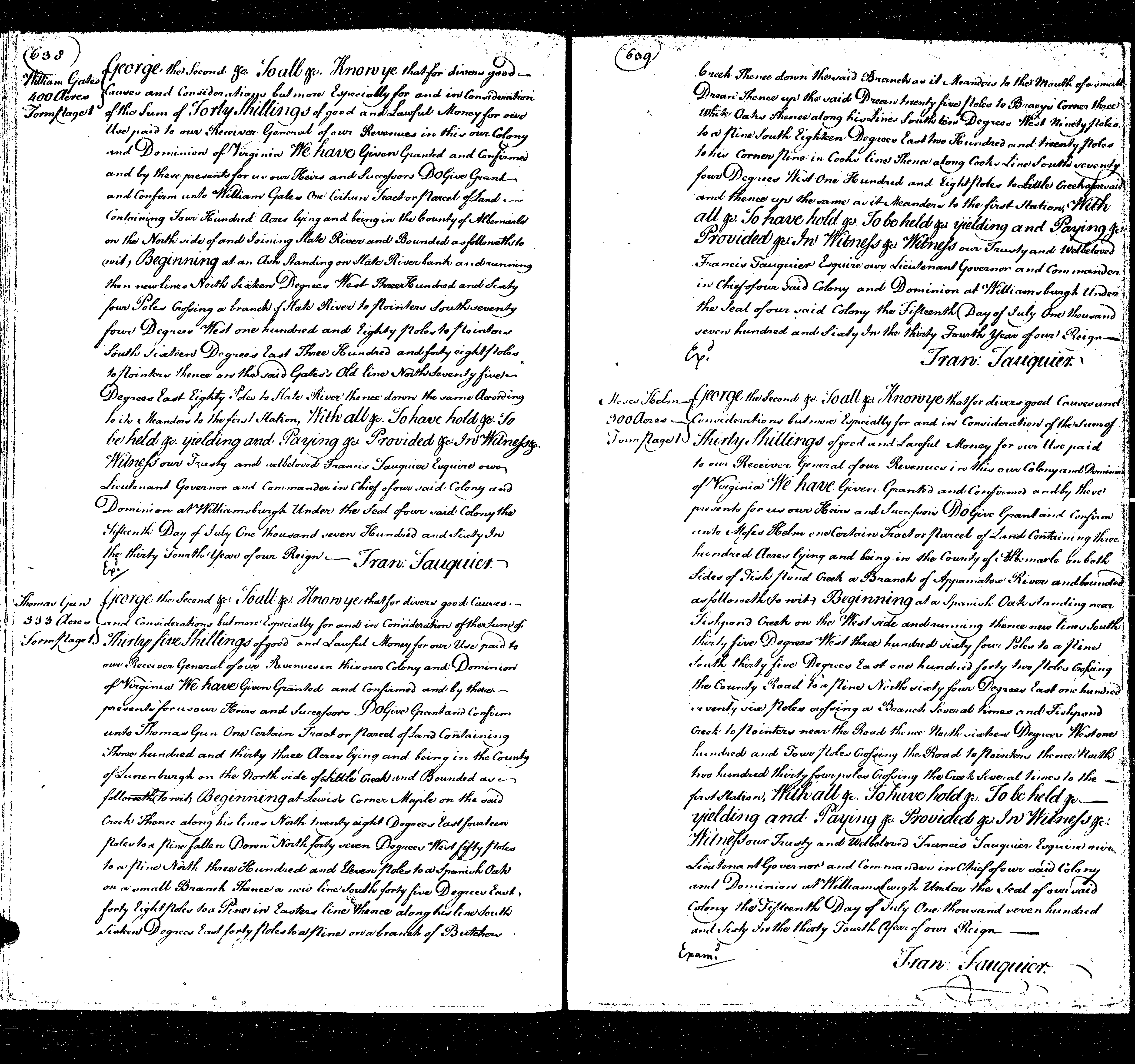
George the Second: To all: Know ye that for divers good Causes and considerations but more Especially for and in consideration fo the sum of thirty shilling of good and lawful money for our use paid to our receiver general of our revenues in this our Colony and Dominion of Virginia we have given granted and confirmed and by these prevents for us our heirs and successors do give grant and confirm unto Moses Helm one certain tract or parcel of land containing three hundred acres lying and being in the county of Albermarle on both sides of Fish Pond Creek a branch of Appomatox River and bounded as followeth (to wit) Beginning at a Spanish Oak standing near Fishpond Creek on the west side and running thence new lines south thirty five degrees west three hundred vialy for poles to a pine south thirty five degrees east one hundred forty two poles crossing the county road to a pine north sialy for degrees east one hundred seveny six poles crossing a branch several times and Fishpond Creek to pointers near the road thense north sixteen degrees west one hundred and four poles crossing the road to pointers thence north two hundred thirty four poles crossing the creek several times to the first station, with all to have hold to be held yielding and paying provided in witness. Witness our trusty and welbeloved Francis Fauquier Esquire our Lieutenant Governor and Commander in Chief of our said Colony and Dominion at Williansburgh under the seal of our said colony the fifteenth day of July One thousand seven hundred and sixty in the thirty fourth year of our reign.
Fran Fauquier
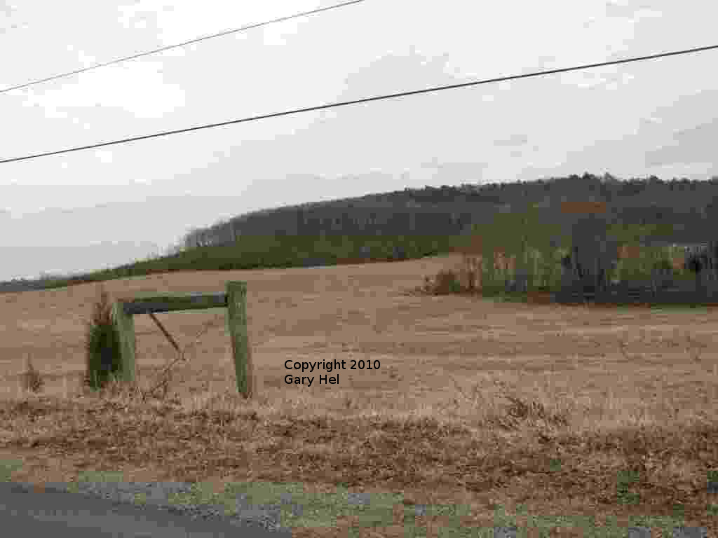
Property at Pilot mountain
The Road Order is dated 1754 and Moses did not purchase the property north of Pilot Mountain until 1757. Obviously Moses was living somewhere when the Road Order was given, before purchasing the Pilot Mountain property from Leerwood in 1757.
Current
day maps show Reedy Creek being on the south side of Pilot Mountain.
The importance of knowing this is, all the Helm properties refer to
Reedy Creek being on the north side of Pilot Mountain, and maps today
show this creek with the name Phebie Creek. There is also a local
campground in the vicinity which names the creek on the north side of
Pilot Mountain, Reedy Creek.
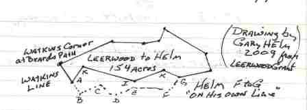
June 13, 1757: Thomas Leerwood acquires, by grant signed by Rob Dinwiddie, 154 acres property in Lunenburg County Virginia. This property will be purchased from Thomas Leerwood on September 24, 1757, by Moses Helm, in Bedford County Virginia. ".. 154 acres to Thomas Leerwood.. in the County of Lunenburg.. on the head branches of Reedy Creek by the north side of Pilot Mountain and bounded as beginning at Watkens Corner on Beards old path..." Here it is worth a note that the property Leerwood obtained a grant for is not, in 1757, in Lunenburg County. In 1753, it became part of Bedford County when Bedford was formed in 1753, and taking into consideration in 1754 part of Albemarlel County was added to Bedford County.10
Thomas Leerwood 154 Acres: Robert Dinwiddie
George the second ~ To all ~ Knowye that for divers good causes and Considerations but more especially for and in Consideration of the sum of Fifteen Shillings of good and lawful Money for our use paid to our Reciever General of our Roven uses in this our Colony and Dominion of Virginia We have given granted and Confirmed and by these prevents for us our Heirs and Successors Do give grant and confirm unto Thomas Leerwood one certain Tract or Parcel of Land containing one hundred and fifty four acores lying and being in the County of Lunenburg on the head branches of Reedy Creek by the North side of the Pilot mountain and ~ bounded as followeth, to wit, Beginning at Watkins Corner pointers on Beards old path thence new lines North sixty five Degrees East one hundred and thirty four poles to a Hicory North eighty five Degrees East seventy four poles to a Hicory North sixty five Degrees East thirty six poles to a white Oak North fifteen Degrees East thirty poles to a white Oak South sixty five Degrees East one hundred and twenty poles to three white Oaks South twenty Degrees East fourty four poles to a Chesnut South seventy five Degrees West seventy six poles to a white Oak North eighty three Degrees West thirty eight poles to a Hicory South seventy Degrees West eighty poles to a white Oak North eighty Degrees West one hundred and forty poles to a white Oak South fifteen Degrees West forty poles to a Spanish Oak in Watkins line and thence along his line North twenty eight Degrees West fifty four poles to the first Station With All ~ To have hold ~ To beheld ~ Yielding and Paying ~ Provided ~ In Witness ~ Witness our Trusty and well beloved Robert Dinwiddie Esquire our Lieutenant Governor and Commander in chief of our said Colony and Dominion at Williamsburg under the Seal of our Colony the thirteenth day of June One thousand seven hundred and fifty seven In the thirtieth year Year of our Reign. Rob: Dinwiddie
September 24, 1757, Bedford Deed Book 1 pp 139-142. Moses Helm's deed is extensively longer than Thomas Leerwood's, and at a cost significantly higher than that paid by Thomas Leerwood for the grant, three months earlier.11
Leerwood to Helm 154 Acres: Thomas Leerwood, Elizabeth Leerwood; Moses Helm
This Indenture made this twenty fourth day of September in the year of our Lord Christ on Thousand seven Hundred & fifty seven Between Thomas Leerwood and Elizabeth Leerwood his wife of the County Prince Edward of the one Part and Moses Helm of the County of Bedford Witnesseth that the said Thomas Leerwood_Elizabeth his wife for and in Consideration of the sum ^[ ]fifty five pounds Current Money of Virginia to him in Hand paid by the said Moses Helm the ~ Reciept whereof they Hereby acknowledge hath given granted Bargained sold Alien'd Enfeoff & Confirmed and by these Presents doth grant Bargain sell Alien Enfe off and confirm unto the said Moses Helm & to his Heirs and assigns forever, One Certain Tract or Parcel of land & lying & being in the County of Bedford on the Head Branches of Reedy Creek containing one Hundred and fifty four acres and is Bounded as followeth to wit Beginning at Waltkens former Pointers on Beard old Path thence New line North sixty five Degrees East one Hundred & thirty^four poles to a Hickory, North Eighty five Degrees East seventy four to a Hickory, North sixty five degrees East thirty six poles to a White oak, North fifteen Degrees East thirty poles to a White oak, North fifteen Degrees East thirty poles to a White oak, South sixty five Degrees East One Hundred and twenty poles to three White oaks, South Twenty Degrees East Forty four Poles to a Chestnut, South seventy five Degrees West thirty eight Poles to a Hickory, South seventy Dregrees West eighty Poles to a White oak, North eighty Degrees West one Hundred & forty Poles to a White oak, South fifteen Degrees West Forty Poles to a Spanish oake in Watkens Line and thence along his Line North twenty eight Degrees West fifty four Poles to the first Station. Together with all Houses, Orchards, Garden, fences, Waters & Water courses way, wood & Underwood, [ ] of its Commodities advantages and all other apperenances Whatsoever to the same Belonging or in any wise appertaining To Have and to hold the aforesaid one Hundred fifty acres of Land Together with the afore Recited Primises and every Tract & Parcel thereof with these & every of their appertenances unto the said Moses Helm his Heirs and assigns forever and the said Thomas Leerwood & Elizabeth his wife for themselves their Heirs Executors and Administraors doth Covenant Grant and agree[ ] with the said Moses Helm his Heirs and assigns that they the said Thomas Leerwood and Elizabeth his Wife and their Heirs Ye^a The above Mentioned Land & Premises is with their and and every of their appertenances unto the said Moses Helm and of his Heirs and assigns forever, To the only Proper use and Behoof of him the said Moses Hoolm and of his heirsforever against him and them the said Thomas Leerwood and Elizab[ ] wife their Heirs Executors and Administ[ ] .. Thomas Leerwood and Elizabeth his Wife hath here unto set their Hands & Affixed their seal the day & year first above [ ] ... Thomas Leerwood his mark Elizabeth Leerwood her mark Witnesses Present Nathanael Peterson, Joseph McAlistery, James Patterson Memorandum that on the twenty fourth day of September One Thousand seven Hundred and fifty seven Quit & Peacable Posision and Siszing of the Land & Simaments within Mentioned was Hoag Taken By the Watken Named Thomas Leerwood and Elizabeth his Wife and by them was Delivered to the Witkin Moses Helm according to the form & Effect of the Wlkin Written Decd Thomas W Leerwood mark Elizabeth W Leerwood mark In the Presence of Nathanael Patterson, Joseph McAlistery, James Patterson Then Rec'd of Moses Helm the [ ] Sum of Twenty five Pounds Current Money of Virginia it being in full the Consideration Money in this Deed Mentioned of me. Thomas W Leerwood mark At a Court held for Bedford County September the [ ] This Indenture and Memorandum [ ].. were provided by the Oaths of Nathaniel Patterson, Joseph McAlistery & James Patterson Witnesses thereto & Orderd to be Recorded ~ Teste Benjamin Howard CBC
March 10, 1767 Bedford County Surveyors Record Book 1 page 93, and Surveyors Record Book 2 page 91: Moses Helm had forty acres north of Pilot Mountain, ajoining his property purchased from Leerwood surveyed. This property is not recorded until it is received as a grant, signed by Thomas Jefferson on September 1, 1780. 12
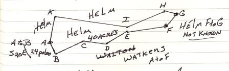
March 19, 1767 Surveyed for Moses Helm 40 Acres Land situated in Bedford County on the North side of the Pilot Maonatin, and Bounded as followeth, viz, Beginning at his own Corner Spanish Oak on Watken's Line, at A, thence from A to B along Watken's Line S28E, 24 Poles to a shrub white Oak; on his line B to C, off, N67E, 58 Poles to a small Red Oak: C to D, S78E, 44 Poles to a Red Oak: D to E, N60E, 48 Poles to a double Red Oak: E to F, N23E, 80 Poles to a Black Jack on an Ivy hill; F to G, N42E 30 Poles to Pointers on his own line: thence along own Lines, G to H, N23@, 24 Poles to his Corner Hicory: H to I, S70W, 80 Poles to his Corner white Oak; I to K, N80W, 140 Poles to his Corner white Oak: and K to A, S15W, 40 Poles to the first Station. By Richard Stith Sur.
September 1, 1780, page 357: It was not until 1780, Moses Helm receives grant for 40 acres north of Pilot Mountain surveyed in 1767.
This property adjoins his property purchased from Thomas Leerwood in 1757. It also adjoins property Thomas Helm received by grant in 1780, which includes Pilot Mountain.
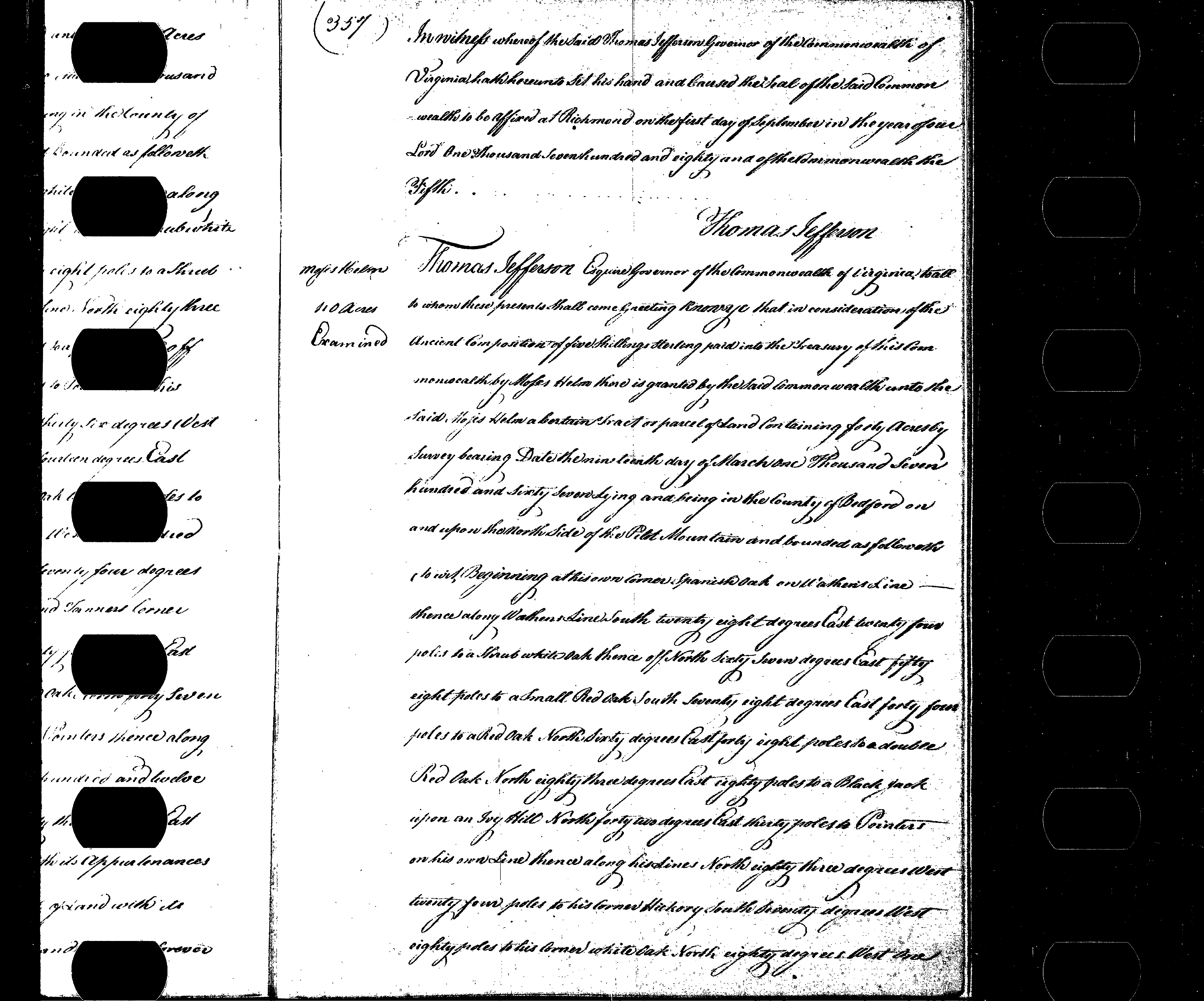
Moses Helm 1 September 1780; 40 acres on the north side of Pilot Mountain
Thomas Jefferson Esquire Governor of the Commonwealth of Virginia to all to whom these presents shall come greeting know ye that in consideration of the ancient composition of five shillings sterling paid into the treasury of this commonwealth Moses Helm there is granted by the said commonwealth unto the said Moses Helm a certain tract or parcel of land containing forty acres by survey bearing date the ninteenth day of March one thousand seven hundred and sixty seven lying and being in the county of Bedford on and upon the north side of the Pilot Mountain and bounded as followeth to wit Beginning at his own corner Spanish Oak on Walthens line thence along Walhens line south twenty eight degrees East twenty fourd poles to a shrub white oak thense off north sixty seven degrees east fifty eight poles to a small red oak south seventy eight degrees east forty four poles to a red oak north sixty degrees east forty eight poles to a double red oak north eighty three degrees east eighty poles to a black jack upon an ivy hill north forty two degrees east thirty poles to pointers on his own line thense along his lines north eighty three degrees west twenty four poles to his corner hickory south seventy degrees west eighty poles to his own corner white oak north eighty degrees west one hundred and forty poles to his corner white oak and south fifteen degree west forty poles to the first station with its appertenances; to have and to hold the said tract or parcel of land with its appartenances to the said Moses Helm and his heirs forever. In witness where of the said Thomas Jefferson Governor of the Commonwealth of Virginia hath hereunto set his hand and cause the seal of the said Commonwealth to be affixed at Richmond on the first day of September in the year of our Lord One Thousand seven hundred and eighty and of the Commonwealth the fifth. Thomas Jefferson
In 1782, Bedford County was divided, and the Helm properties near Pilot Mountain became part of Campbell County, portions of which, after 1845 may have become part of Appomattox County.13
Part of the 1757, 1767 and 1780 survey lines in the Moses Helm and Thomas Helm properties are still in use today, and are visible in satellite photos.
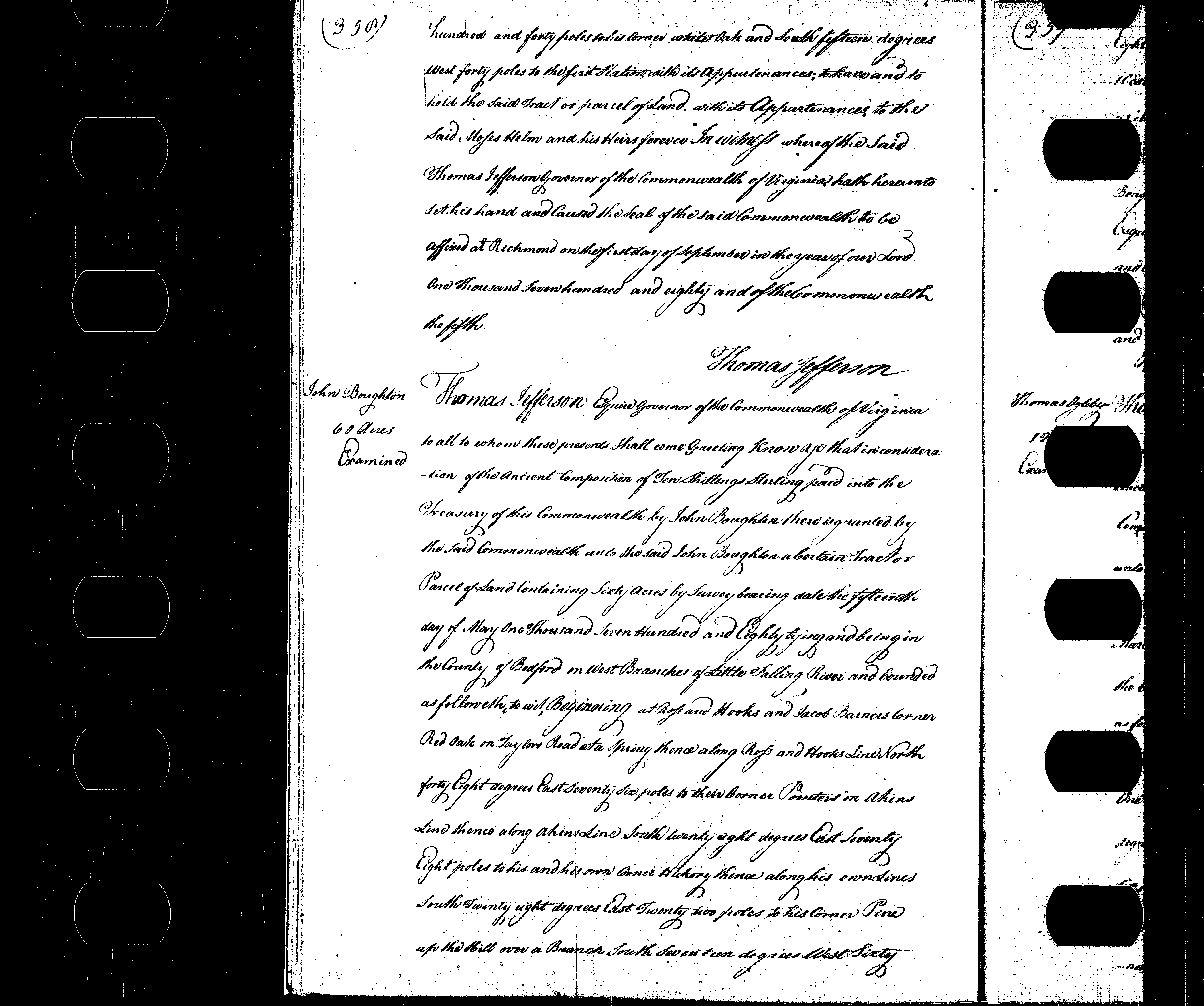
In 1789, John Helm sold 300 acres in Buckingham County Virginia to Edward Petteson. This property may have been the 300 acres Moses Helm obtained by grant in 1760, as that property was in Buckingham County which would later become part of Appomattox County.14
In 1800, John Helm sold 194 acres on the headwaters of Reedy Creek to James Helm. This would have been the 154 acres Moses Helm purchased from Thomas Leerwood in 1757 and the 40 acres property surveyed in 1767 and granted in 1780.
The family myth is John sold this property to his son James, when in fact John sold this property to Thomas’ son, James, proven by the fact James and Sarah, not James and Mary, later sold part of the property John’s sister Jane, and another part of the property to Thomas Gordon.
Helm to Helm, 1800, 194 Acres
This Indenture made this thirteenth Day of May in the year of our Lord Christ one thousand and eight hundred between John Helm and Mary Helm his wife of the one part of the County of Campbell and common wealth of Virginia and James Helm of the said County and common wealth of the other part, Witnesseth that the said John Helm and Mary his wife for and in consideration of the sum of two hundred dollars current money of Virginia to them in hand paid by the said James Helm the receipt thereof they do hereby acknowledge and therefore hath given granted bargained and sold aliened enfeoffed and confirmed and by these presents doth grant bagain and sell alien enfeoff and confirm unto the said James Helm his heirs and asigns forever one certain Tract or parcel of land lying and being in the County of Campbell aforesaid on the head branches of Reedy creek containing one hundred and ninty four acres be the same more or less one hundred and fifty four acres of which land was purchased of Thomas Leerwood by Moses Helm in the year one thousand seven hundred and fifty seven The other forty acres was an Entry made by the said Moses Helm adjoining the aforesaid Tract for which a patent or grant Issued to him for the same from the secretarys office bearing date the first day of September in the year one thousand seven hundred and eighty the aforesaid one hundred and ninty four acres of land being baounded as follows to wit, Beginning at a place formerly known to be Watkens Corner pointers on beards old path thence New lines North sixty five degrees East one hundred and thirty four poles to a hickory North Eighty five degrees East seventy four poles to a hickory North sixty five degrees East thirty six poles to a white oak North fifteen Degrees East thirty poles to a white oak South sixty five degrees East one hundred and twenty poles to three white oaks south twenty Degrees East fourty four Poles to a chesnut South seventy five degrees West seventy six poles to a white oak North eighty three degrees West fourteen poles to pointers & it being the place where the line of the entry of forty acres intersects the lines of the old survey thence along the line of the Entry South forty two Degrees West thirty poles is a black Jack on Ivy hill thence southeighty three degrees West eighty poles to a double red oak thence south sixty degrees West forty eight poles to a red oak thence North seventy eight degrees West fourty four poles to a small red oak Thence south sixty seven degrees West fifty eight poles to a shrub white oak on Watkens old line thence north twenty eight degrees West twenty four poles to a Spanish oak. And thence along his line North twenty eight degrees West fifty four poles to the first Station Together with all houses orchards gardens fences waters and water courses wasys woods and under woods profits commodity's advantages and all other appertenances whatsoever to the same belonging or in any wise appertaining To have and to Hold the aforesaid One hundred and ninty four acres of land together with the aforesaid Recited Prenises and every part and parcil thereof with their and ever every of - their appurtenances unto the said James Helm his heirs and assigns forever and the said John Helm and Mary his wife for themselves their heirs Executors and administraters doth covenant and agree to and with the said James Helm his heirs and assigns that they the said John Helm and Mary his wife their heirs & the above mentioned lands and premises with their and every of their appurtenances unto the said James Helm his heirs and assigns for ever To the only proper us and behoof of him the said James Helm and of his heirs forever against him and them the said John Helm and Mary his wife their heirs Executors and Administrators and against all other persons whatsoever shall and will warrant and for ever by these presents defend. In witness whereof the said John Helm and Mary his wife hath here unto set their hands and affixed their seals the days and year first mentioned above written~ Signed sealed and delivered John Helm Mary Helm In the Presnece of At A Court Held for Campbell County June 9th 1800 This Indenture was acknowledged by John Helm and Mary his wife she having been first privily examined according to Law and Ordered to be Recorded Teste Ro Alexander CCC mailed [Mss] RB Clayton
Some attribute this sale being to James Helm, the son of John, but it could also have been sold to James Helm the son of Thomas Helm, Thomas having obtained grant to the adjoining property in 1780. James, the son of Thomas Helm, married Sarah Watkins during 1797 in Campbell County. She was the daughter of Moses Watkins, a near neighbor of the Helm family. The extended Watkins family, including James and Sarah moved from Virginia, sometime between 1806 after James and Sarah son Moses Watkins Helm was born in Virginia and 1808 when their daughter Patsy was born in Clarke County Georgia, and later to Tennessee. James the son of John Helm also moved, to Kentucky and later to Tennessee.
Helm to Helm, 1801, 60 Acres
This Indenture made this eighth day of October in the year of our Lord Christ one thousand eight hundred and one Between James Helm and Sarah Helm his wife of the County of Campbell of the one part and Jane Helm of the said County and state of the other part Witnesseth that the said James Helm and Sarah his wife for and in consideration of the Sum Thirty Six pounds current money of Virginia to them in hand paid by the said Jane helm the receipt thereof they hereby acknowledge and also that they hath given granted bargained sold aliened enfeoffed and confirmed and by these present doth grant bargain sell alien enfeoff and confirm unto the said Jane Helm and heirs and asigns for ever one certain Tract or parcel of Land lying and being in the County of Campbell aforesaid on the head branches of reedy creek containing about sixty acres be the same more of less and bounded as follows to wit, Beginning at a black oak and post oak on or near the line which divides the lands of said James Helm and David Ross then running by a line made and agreed on between said James Helm and Sarah his wife on the one part and and the aforesaid Jean Helm on the other part running about south Twenty or thirty degrees East by several marked Trees to an old field then through the old field nearly the same course to a hickory Tree at the fork of a branch then up the most easterly branch of the bra on the east Side nearly a South course by marked trees to a large Gum near James Robertsons line and so on until it intersects the said line and then to follow the lines of the said James Helm around on the West side of the said divideing line to the first Station so as to Include all that part of his Tract of land which lyes on the west side of the dividing line aforesaid at the west end of his plantation together with all houses orchards gardens finces waters and water courses ways woods and underwoods profits commodities advantages and all other appertenances whatsoever to the same belonging or in any wise appertaining To have and to Hold the aforesaid Tract or parcel of land together with the before recited pronises and every part and parcel therof with their and every of their appurtenances unto the said Jean Helm her heirs and asigns forever and the said James Helm and Sarah his wife for thenselves their heirs Executors administrators & doth covenant to and with the said Jane Helm her heirs and asigns that they the said James Helm and Sarah his wife and their heirs &c the above mentioned lands and premiseis with their and every of their appurtenances unto the said Jane Helm her heirs and assigns forever to the only proper use and heoof of her the said Jane Helm and of her heirs forever against him and them the said James Helm and Sarah his wife their heirs executors and administrators and against all other persons whatsoever shall and will warrant and forever by these presents defend [ ] whereof the said James Helm and Sarah his wife hath hereunto set their hands and affixed their seals the day and year first above written James Helm Sarah x Helm her mark At a Court held for Campbell County October 12th 1801 This Indenture was acknowledged by James Helm and Sarah his wife she having been first privily examined according to law and ordered to be Recorded Teste Re Alexander CCC
Helm to Gordon, 1802, 135 Acres
This Indenture made this ninteenth day of June in the year of our Lord Christ one thousand eight hundred and two between James Helm and Sarah Helm his wife of the County of Campbell and State of Virginia of the one part [ ] Thomas Gordon of hte County of Prince Edward and State afore[ ] of the other part Witnesseth that the said James Helm and Sarah his wife for and in consideration of the sum one hundred and twenty pounds Virginia money to them in hand paid by the said Thomas Gordon the receipt whereof they do hereby acknowledge and therefore hath given granted bargained sold aline accfeofed and confirmed and by these presents do grant bargain sell alien enfioff and confirm unto the said Thomas Gorden his heirs and asigns forever one certain Tract or parcel of land lying and being in the County of Campbell on the head brances of Reedy Creek containing one hundred and thirty five acres be the same more or less and bounded as followeth to wit, Beginning at a black Jack on Ivy hill it being a corner tree of a tract of land of Forty acres which was Surveyed for Moses Helum Surv the nineteenth day of March one thousand seven hundred and sixty seven running thence South eight Degrees West eighty poles to another corner of the above mentioned Survey of land which corner was a double red oak but is distroyed thence South fifty seven degrees West thirty one poles to Jean Helm line thence along her line North five degrees West Sixty Six poles to a corner hickory at the fork of a branch then north forty degrees north fourth degrees West fifty three poles to a new corner then north sixty one degrees East along the line of Helms old Survey ten poles to where there stood a corner hickory but is destroyed thence north eighty one degrees East Seventy four poles to a corner hickory on the same old line but is destroyed and thence north eleven degrees East thirty poles to where there stood a corner white oak that is destroyed then South Sixty nine degrees East one hundred and twenty two poles to three corner white oaks then South twenty four degrees East fourty six poles to a corner chesnut then South Seventy one degrees West eighty poles to a corner white oak then north eighty seven degrees West forteen poles to pointers on same old line at the place where ^the line of Helm's survey of fourty acres Intersects the other thence off along the line of the new survey of forty acres South thirty nine degrees West thirty two poles to the first Station ... Signed Sealed and delivered James Helm Sarah + Helm her mark In the presnce of Zachariah Hargrove William Hargrove Wm Hargrove At a Court held for Campbell County October 11, 1802 This Indenture was acknowledged by James Helm and Sarah his wife she having been first privily examined according to law and ordered to be Recorded Teste Ro Alexander CCC
Helm, 18 , 60 Acres to be sold by public auction
CONCORD PRESBYTERIAN CHURCH
MYTH 3
1757,
one of the oral family tradition is, Moses Helm gave property for
building (Old) Concord Presbyterian Church, and the earliest
cemeteries of the church was on the property given by Moses Helm.
Old Concord Presbyterian Church reports an earlier date 1735 for its founding. That date is also the date Hat Creek Presbyterian Church, which is the earliest Presbyterian Church in Virginia, was established.
By the early 1800’s few relatives of the Helm family were members of (Old) Concord Presbyterian Church
OTHER INFORMATION ABOUT MOSES HELM
Moses Helm: Born early 1700's (c.1711 or before); Died late 1700's (after 1781, before 1789). Married Sarah Jamison (Jameson) c. 1739 or before; Sarah was born c.1711 and died c.1812.
The children of Moses Helm and Sarah Jamison Helm are: Elizabeth Helm, born November 15, 1739; she died before 1786. John Helm: born August 14, 1741; he died April 20, 1826. Mary Helm: born October 23, 1743; she died February 18, 1837. William Helm: born September 11, 1745; he died c.1768. Thomas Helm: born July 22, 1748; he died March 15, 1781. Susannah Helm: born June 15, 1750; she died c1836. Jane Helm: born May 25, 1752; she died April 1825. Sarah Helm: born October 8, 1755; she died January 11, 1843.
1738: a Moses Helm and Thomas Helm witness signing a document in Belfast Ireland for William Lin of Basking Ridge (NJ) to serve as Power of Attorney for widow.
Ann Drennan of Donogore, County Antrim widow, appoints as her attorney William Linn of Baskingridge NJ, weaver, to recover debts due the account of her husband Gilbert Drennan, late of Cecil County, deceased, schoolmaster. Ann Drennan alias McMurtry of Donegore made oath she was married to the within named Gilbert Drennan for about 20 years preceding April 1729 when he transported himself to America and that she had been informed her husband had lately died in Cecil Co. and that William forster of said place had obtained letters of administration to the effects of her husband without her approbation or consent. She desires that hist assets and effects be deposited in the custody of said William Linn for her use. Made and attested to 24 July 1738 in Belfast by Margotson Saunders. Wit. Moses Helm, Thomas Helm. Ackn in Cecil Co 6 Jan 1740 by Thomas Helm who was present in Belfast Ireland and saw Ann Drennan sign and seal this power of attorney. JP Wm Ramsey. Rec. 24 Jan 1740 Wm Knight Clerk. 16
There is a Christopher Helm living in Basking Ridge. His grave and other graves of his wife and other family members are buried in the Basking Ridge Presbyterian Church cemetery. Christoper was born in 1648, and the ages of other family members buried there gives the impression they are more likely to be his grand-chilren. If there are any connections between Christopher Helm and Moses Helm, these have not been found.17
Tradition is, Moses Helm migrated to the colonies around 1738.
November 15, 1739, Elizabeth Helm is born to Moses and Sarah Helm.
1740: in Baltimore MD, Thomas Helm registered the document mentioned above, which he and Moses Helm signed in Belfast.18
1740: a Moses Hellim bought property in Piscataway Middlesex (NJ) from... Moses Helm was a weaver. . 19
Matthias Smock House is a National Landmark in Piscataway, having been built c.1720.20
August 14, 1741: John Helm is born to Moses and Sarah Helm.
October 23, 1743: Mary Helm is born to Moses and Sarah Helm.
1744: [needs verified] Moses Hellim owned a lot in Winchester Virginia.
In the Frederick County Virginia area there was a Joseph Helm living in Strasburg, and Gorge Helm (German) who lived in Winchester. The grave stone of Gorge Helm is said to be the oldest known marker in the area, and is in the Reformed Lutheran Cemetery.
Other references to confirm:
Frederick County Deed Book 1 pages 112-113, Stephens City May 16, 1762;
Fredericks County Will Book 3 page 479, Winchester, February 25, 1769.
September 11, 1745: William Helm is born to Moses and Sarah Helm.
July 22, 1748: Thomas Helm is born to Moses and Sarah Helm.
June 17, 1750: Susannah Helm is born to Moses and Sarah Helm.
May 25, 1752: Jane Helm is born to Moses and Sarah Helm.
1754: Letters for Moses Helm and Christopher Helm are listed in (NJ) Post Office.21
October 8, 1755: Sarah Helm is born to Moses Helm and Sarah Helm.
1757: Letters for a Moses Helm are listed in the (NJ) Post Office.22
May 15, 1758: Elizabeth Helm is born to Moses and Sarah Helm.
Sarah
Helm, wife of Moses Helm, died in 1812.
1
Bedford County Court Book 1 page 23
2
Virginia Department of Transportation, Histories of Roads in Virginia,
LUNENBURG COUNTY ROAD ORDERS 1746-1764; pdf 93-r17
3
Virginia Department of Transportation, Histories of Roads in Virginia,
Albemarle COUNTY ROAD ORDERS
4
Virginia Library Website, description of who were tithables
5
Breaking the Backcountry: The Seven Years' War in Virginia and
Pennsylvania, 1754 – 1765; Matthew C. Ward, University of Pittsburg
Press, Pittsburg, PA 15260, 2003, page 71.
6
Ibid, page 148
7
Ibid, page 166
8
Ibid, pages 195-196
9
Ibid, page 199
10
Lunenburg County Virginia, Thomas Leerwood
11
Bedford Deed Book 1 pp 139-142
12
Bedford County Surveyors Record Book 1 page 93, and Surveyors Record
Book 2 page 91
13
40 acres
14
Helm to , 17 , 300 Acres in Buckingham County, Burnt County Records
recovered
15
And assorted records of presbytery meetings including meetings of old
Concord dating to c. 1735 http://books.google.com
16
Abstracts of Cecil County Maryland Land Record 1673-1751, June D.
Brown, page 218;
http://books.google.com
17
Baskingridge Presbyterian Church
18
Cecil County Records
19
Piscataway deed
20
Matthias Smock
House is a National Landmark